Add Location in SketchUp for Desktop
The Add Location feature in SketchUp helps make adding and managing geo-location imagery and data easy. Here, we'll cover how to import imagery, view terrain, locate your model, and delete imagery in SketchUp for Desktop.
Importing Map Imagery
To get started, select File > Add Location from the Menu bar.
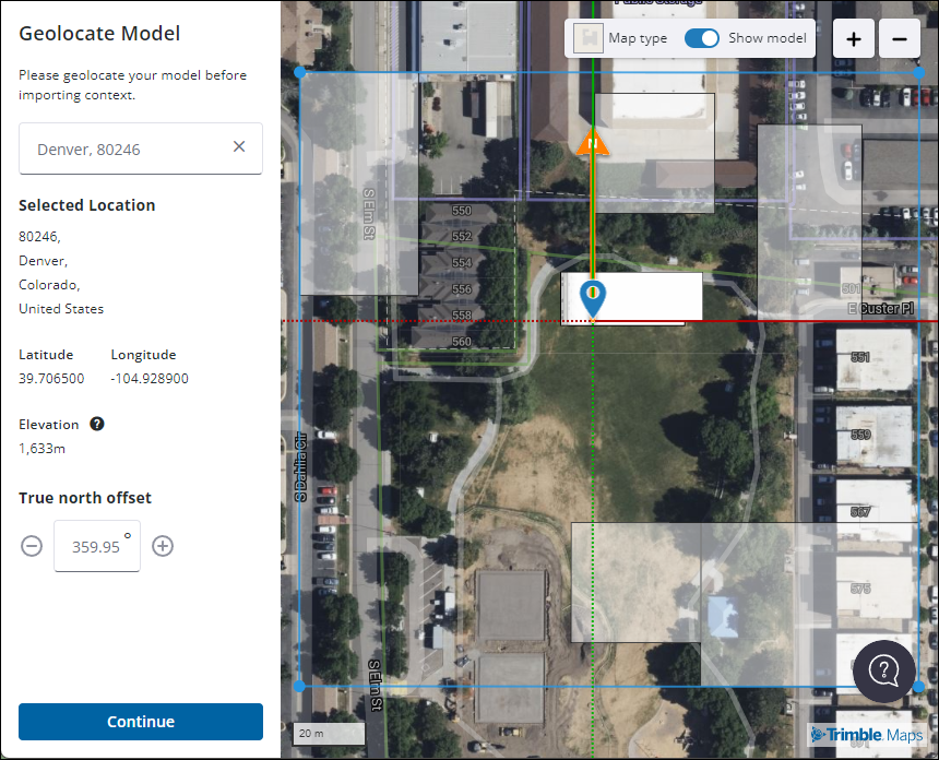
The Add Location window will appear. To get started you’ll need to narrow down your location. You can type in an address or a location name in the box provided. As you type, SketchUp will offer suggestions to match what you have entered. After choosing a location you’ll see a map of that location with your model placed in the center and an arrow designating True North. You’ll also see its latitude, longitude, and True North offset.
You can use the controls in the upper right of the window to zoom in or out, change the view between a basic street map and a satellite/aerial view, or toggle the visibility of your model.
Once you are ready to proceed, click Continue to Add Site Context.
In Add Site Context you can designate the following options:
- Import Type – Choose between 2D Plane or 3D Terrain. If 3D Terrain is selected you can also adjust the mesh density. Higher density allows for more triangles/customization but increases file size.
- Map Texture – Choose between Street Map or Satellite. You can also adjust the resolution between low, medium, and high.
Resolution | Best for |
Low | Visualizing large areas of context scenery without affecting performance. |
Medium | Visualizing proximate context scenery. |
High | Adding detailed scale site imagery for presentation or tracing. |
- Image Provider - SketchUp offers both Digital Globe and Bing for geo-location data. Click a provider name in the Region panel to choose your preferred provider.
Digital Globe | Bing | |
Image type | Satellite | Satellite |
Resolution | Low | High |
Platform availability | Desktop & iPad | Desktop |
On the map you can adjust the size and shape of the region that will be imported into your model. Click and drag the edges of the box to resize it, or use the grip on the side of the box to move it.
Once you have adjusted everything the way you want it, click Import Site Context. Add Location will import everything into your model. You have successfully geolocated and added site context your model!
Viewing Terrain
Add Location can also import terrain data into your model. To help you manage the visibility of terrain data Add Location uses Tags.
All terrain data appears in the Tag hierarchy under Geolocated Content. 2D Plane and 3D Terrain are their own entries, allowing you to switch as needed. Each import creates new tags for easier tracking.
For more information on how you can use 3D data to create other terrain representations, see Sculpting and Fine-Tuning Terrain or Placing Models and Objects on Your Terrain.
Adding More Imagery
After importing map imagery, you can always add more without changing the location you've already established for your SketchUp model. Open Add Location again and click Add More Context.
Deleting Imagery
To delete imported map imagery, use the Select tool and select the imagery. Unlock the imagery using Edit > Unlock > Selected or select Unlock from the context menu. Once the imagery is unlocked, you can delete the imagery just like you would any other geometry within your model.
Using Your Own Image
SketchUp allows you to replace the topography and images generated by Add Location with your own image. After using Add Location, import the image you would like to add to your model. You can then use vertical lines drawn from identifiable landmarks to match the scale and position of your image with the one generated by Add Location.
To make things appear a bit more seamless, use the Sample Material mode (Alt on PC, Command on Mac) of Paint Bucket tool () on your imported image. You can then use the Drape mode of the Sandbox tool to further modify your image. Once you've set up your imported image, you can switch on terrain and repeat the process.